
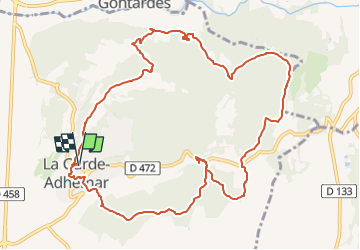
Autour de La Garde-Adhémar

thonyc
User GUIDE

Length
12.7 km

Max alt
233 m

Uphill gradient
306 m
Km-Effort
16.7 km

Min alt
84 m

Downhill gradient
307 m
Boucle
Yes
Creation date :
2022-08-17 08:48:47.641
Updated on :
2022-08-19 13:27:29.639
3h45
Difficulty : Medium

FREE GPS app for hiking
 SityTrail
IGN / Geographical institutes
SityTrail Plus
The world is yours!
About
Trail Walking of 12.7 km to be discovered at Auvergne-Rhône-Alpes, Drôme, La Garde-Adhémar. This trail is proposed by thonyc.
Description
Le village et ses jardins suspendus, le val des nymphes, les cuves lapidaires, les ocres rouges.
Circuit très varié avec beaucoup de curiosités.
Photos


Positioning
Country:
France
Region :
Auvergne-Rhône-Alpes
Department/Province :
Drôme
Municipality :
La Garde-Adhémar
Location:
Unknown
Start:(Dec)
Start:(UTM)
639704 ; 4917141 (31T) N.
Comments